Locating Existing Planters
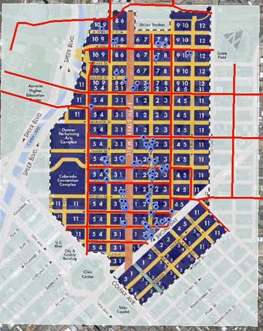
Our field research team consisted of 4 planners. Before we could prescribe locations, we first had to locate and survey all 175 existing planters within Denver's Business Improvement District (BID) assessment area. One planner photographed the planters using a camera with geo-tagging capabilities. Another plotted the approximate locations of existing planters on a paper map. The remaining two planners took contextual photos of these areas, made notes about physical features, and recorded qualitative assessments of potential areas for the new planters. Afterward we placed the geo-tagged digital photos on Google maps and posted the map of the existing planters on a website.
Rationale for Proposed Planters
Next we devised a methodology for determining locations for the 170 new planters. We created a rational framework for prioritizing and ranking streets and blocks within the BID assessment area by considering the following:
1. Tax Assessments from the Downtown Denver Partnership BID Assessment Methodology Map for Calendar Year 2010 (see Figure 2 below) We assigned points in the following manner:
2. Level of Streetscaping as shown on the Downtown Denver Area Plan. We assigned points in the following manner:
3. Priority street Status from the Priority Street Framework Map - Downtown Denver Area Plan. We assigned points in the following manner:
Streets with the highest average point score received the highest priority of planter placement. Then the individual blocks within those streets with the highest average score received the highest priority for planter placement (see “Street Hierarchy for Planter Prioritization”). We believe this ranking system is useful not only for this phase of new planters, but should also be used for determining planter locations for future phases as well.
We weighted category #1-Tax Assessment and category #2-Level of Streetscaping more heavily than category #3-Priority Street (categories #1 & 2 could receive 3 possible points while category #3 could only receive 1 possible point). We weighted the categories in this manner because we felt that there was a cohesive spatial structure for categories 1-2, while category #3 was dispersed and fragmented.
Additionally, if there were streets with very close scores and we needed to decide which street to place planters, we prioritized streets based upon fulfilling two goals:
1. Momentum - Build upon the momentum of the bulk of the existing planters on 17th Street with the goal of finishing off this street before beginning other large, high ranking streets such as 14th Street and 18th Street.
2. Linkages - Propose planters in an orderly, designed fashion to create linkages between key streets, places and institutions (i.e. between 16th Street Mall and the Cultural Arts complex and Convention Center, extending the planters on 17th Street up to Union Station).
Applying the Formula
Our methodology for documenting the proposed planter locations was to first locate the streets and blocks receiving the highest average scores on Google Maps. Then, we narrowed down specific sites using the Google “Street View” feature. This gave us a rough idea of where to place planters without conflicting with existing street furnishings such as street lights, parking meters, trees, utilities, etc. We field verified the proposed planter areas for general feasibility, but a detailed field verification should occur prior to actual placement of the planters. This final level of fieldwork is necessary because of the limited visibility.
APPENDIX
Below are the charts, tables, and maps which support our final planter placement recommendations. A map of actual reccomendations is available in the "Planters" tab on the left of this page.
NOTE: Figure 1 may be fully displayed by selecting the "scroll" button on the lower left corner of the document.
Our field research team consisted of 4 planners. Before we could prescribe locations, we first had to locate and survey all 175 existing planters within Denver's Business Improvement District (BID) assessment area. One planner photographed the planters using a camera with geo-tagging capabilities. Another plotted the approximate locations of existing planters on a paper map. The remaining two planners took contextual photos of these areas, made notes about physical features, and recorded qualitative assessments of potential areas for the new planters. Afterward we placed the geo-tagged digital photos on Google maps and posted the map of the existing planters on a website.
Rationale for Proposed Planters
Next we devised a methodology for determining locations for the 170 new planters. We created a rational framework for prioritizing and ranking streets and blocks within the BID assessment area by considering the following:
1. Tax Assessments from the Downtown Denver Partnership BID Assessment Methodology Map for Calendar Year 2010 (see Figure 2 below) We assigned points in the following manner:
- 3 points for Assessment Categories #1-3
- 2 points for Assessment Categories #4-6
- 1 point for Assessment Categories #7-9
- 0 points for Assessment Categories #10-12
2. Level of Streetscaping as shown on the Downtown Denver Area Plan. We assigned points in the following manner:
- 3 points for the LoDo level streetscaping
- 2 points for the Level 2 streetscaping
- 1 point for the Level 1 streetscaping
- 0 points for indication of streetscaping
3. Priority street Status from the Priority Street Framework Map - Downtown Denver Area Plan. We assigned points in the following manner:
- 1 point for "Yes"
- 0 points for "No"
Streets with the highest average point score received the highest priority of planter placement. Then the individual blocks within those streets with the highest average score received the highest priority for planter placement (see “Street Hierarchy for Planter Prioritization”). We believe this ranking system is useful not only for this phase of new planters, but should also be used for determining planter locations for future phases as well.
We weighted category #1-Tax Assessment and category #2-Level of Streetscaping more heavily than category #3-Priority Street (categories #1 & 2 could receive 3 possible points while category #3 could only receive 1 possible point). We weighted the categories in this manner because we felt that there was a cohesive spatial structure for categories 1-2, while category #3 was dispersed and fragmented.
Additionally, if there were streets with very close scores and we needed to decide which street to place planters, we prioritized streets based upon fulfilling two goals:
1. Momentum - Build upon the momentum of the bulk of the existing planters on 17th Street with the goal of finishing off this street before beginning other large, high ranking streets such as 14th Street and 18th Street.
2. Linkages - Propose planters in an orderly, designed fashion to create linkages between key streets, places and institutions (i.e. between 16th Street Mall and the Cultural Arts complex and Convention Center, extending the planters on 17th Street up to Union Station).
Applying the Formula
Our methodology for documenting the proposed planter locations was to first locate the streets and blocks receiving the highest average scores on Google Maps. Then, we narrowed down specific sites using the Google “Street View” feature. This gave us a rough idea of where to place planters without conflicting with existing street furnishings such as street lights, parking meters, trees, utilities, etc. We field verified the proposed planter areas for general feasibility, but a detailed field verification should occur prior to actual placement of the planters. This final level of fieldwork is necessary because of the limited visibility.
APPENDIX
Below are the charts, tables, and maps which support our final planter placement recommendations. A map of actual reccomendations is available in the "Planters" tab on the left of this page.
NOTE: Figure 1 may be fully displayed by selecting the "scroll" button on the lower left corner of the document.
Figure 1: Street Hierarchy
Figure 2: Tax Assessment of Existing Businesses in the BID
Legend for BID Map
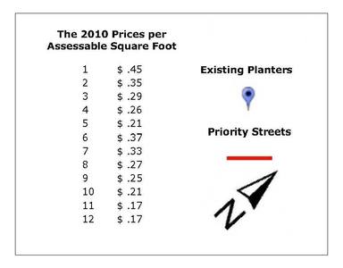
Table of BID Map Data